Severe weather season is off and popping in Middle Tennessee, and we have ourselves a potentially significant severe weather event on our hands for today and tomorrow.
Friday, March 14
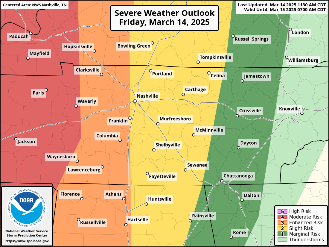
We have been given an Enhanced Risk (a 3 on the scale of 0-5) for storms in the OVERNIGHT HOURS. To break down the risks:
- 10% chance of a tornado, and if a tornado happens there is a 10% or greater chance it could be a strong tornado (EF2 or greater).
- 30% chance of damaging winds of 58+mph, with a 10% or greater chance of significant wind gusts of 74+mph or greater.
- 15% chance of hail 1 inch or greater in diameter.
**ALL OF THESE RISKS are within 25 miles of a point**
FLOOD WATCH: 9pm Friday to 1am Sunday – lots of rain expected with these storms, including some training could lead to flooding and potentially flash flooding event.
WIND ADVISORY: 10pm Friday to 7am Saturday – wind gusts out of storms will be strong overnight, giving us gradient winds and gusts of 40-45mph or greater that could cause some damage outside of storms.
TIMING: Current thinking on timing for Friday is 12am-3am, but always give or take a bit from this timeframe.
UNCERTAINTIES: If you’ve been following along on social media, I mentioned there may be a “cap” in place (a layer of warm air aloft that helps “cap” storms from reaching their full severe potential). NWS is no longer worried about this cap which means the potential for severe weather has increased.
Saturday, March 15
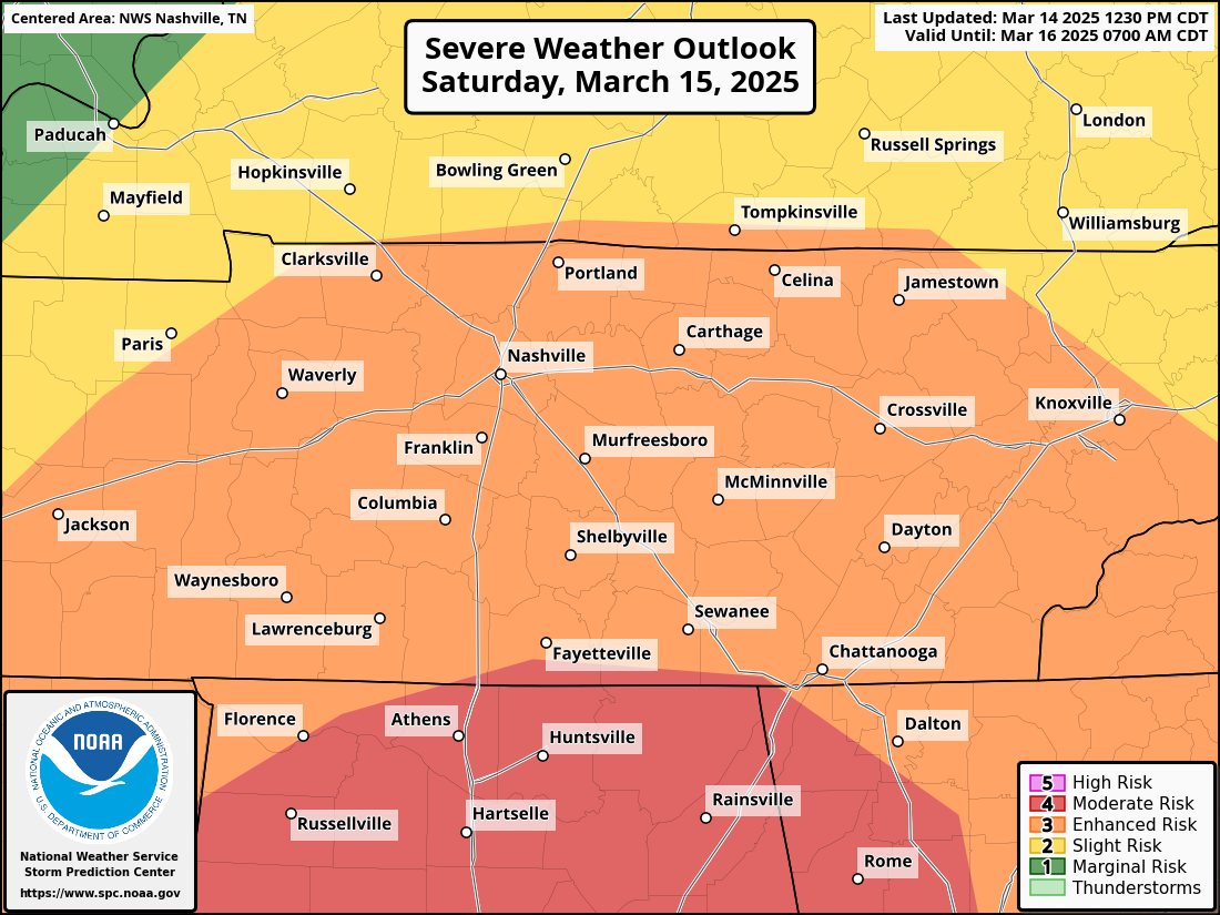
We are yet again in the Enhanced Risk (3 on a scale of 0-5) for Saturday.
Here are those risks:
- 10% chance of a tornado, and if a tornado happens there is a 10% or greater chance it could be a strong tornado (EF2+ or greater).
- 30% chance of damaging winds of 58+mph or greater
- 15% chance of hail 1 inch in diameter or greater, with a 10% or greater chance of hail 2 inches in diameter or greater.
TIMING: This is messier in terms of timing because there could be some early morning storm activity or a lull in the activity. It’s best to say this will be an ALL DAYLIGHT HOURS and some EVENING HOURS SATURDAY event.
UNCERTAINTIES: We are watching a warm front for Saturday. If it tracks more into Middle Tennessee and north of us, then it increases our risk of severe weather for Saturday. If it stays and stalls on the TN/AL border or even stays in AL, that helps limit our potential for *the worst* of the severe weather, but not eliminate it completely.
FOR BOTH EVENTS
We are going to be under the threat of severe weather for around a 24 hour period, with multiple rounds of severe weather coming through.
Even though I just outlined the risks and they are slightly different from day to day, in all honesty the entire event should be treated the same: damaging winds, large hail, tornadoes, flooding (in that order) are the risks, and they are a bit higher risks than we are normally used to in Middle Tennessee.
MODELS: Models are in agreement in some ways, and not in others. Some models are showing kind of a “bust” event, while others are showing a more “boom” event. I always root for the bust event (meaning, nothing happens), but more and more signals are showing the potential for this to be a boom event (meaning we are going to see some rough stuff).
BE PREPARED: Especially because Friday is an overnight event while all of us are sleeping (or should be), have a way to wake yourself up should you find yourself in a tornado warning and need to take shelter. A weather radio, wake me up app, or having someone pull the nightshift in your household are really recommended overnight Friday and potentially some on Saturday night.
STAY TUNED
Stay tuned to *trusted* weather sources. This particular event has made a lot of armchair weather folks come out of the woodwork online sharing worst case things on social. Stick to trusted sources of weather information.